

Preliminary results obtained during the 60th voyage of the R/V Akademik Nikolay Strakhov to the Barents Sea, which concluded in November, identified large sand ridges up to 8 meters high at sites near Kolguyev Island and the Kanin Peninsula, formed by hydrophysical processes. Scientists from Shirshov Institute of Oceanology of the Russian Academy of Sciences have established that the predominant direction of sediment transport in this area is from south to north. Preliminary data suggest the rapid movement of a significant volume of sediment across the seabed along this zone, and the migration and changes in the characteristics of sand waves pose a hazard to navigation. Further development of these processes could lead to the exposure of underwater communications, increasing the risk of damage to pipelines and cables located on the seabed.
Furthermore, geophysical surveys, including multibeam echo sounding and seismic profiling, allowed the identification of landform complexes of glacial and fluvioglacial origin. Scientists paid particular attention to the study area north of Cape Kanin Nos, where a suspected meltwater drainage channel and areas of hilly and ridged relief formed by ancient glaciers were discovered. The morphology of the seafloor landforms near Kolguyev Island indicates their moraine origin, and the new data obtained will help clarify the boundaries of the ice sheet in the region.
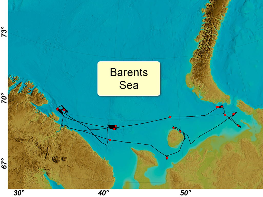
The vessel's route during the 60th voyage of R/V Akademik Nikolay Strakhov.
The stations completed are shown in red circles.
An important part of the research was the study of zones of increased gas saturation and ice gouging. Anomalies associated with degassing were discovered, including gas flares, bright spots, and vertical acoustic brightening in the sedimentary cover. These manifestations were particularly numerous in the eastern Pechora Sea. The released gas flows can generally weaken the structure and stability of bottom sediments, suggesting they pose potential geohazards during the construction and operation of underwater infrastructure.
Degassing processes have led to the formation of pockmarks—microcraters 45 meters in diameter and over 5 meters deep—in the area of the Rybachy Peninsula. The location of these formations coincides with areas of increased thickness of underwater sediments, predominantly silty-pelitic muds.
Scientists also identified ice gouges at depths ranging from 95 to 270 meters. Oceanographers estimate that the maximum depth at which modern ice gouging occurs in the Barents Sea does not exceed 180–200 meters. Ice gouges discovered at greater depths are relict, likely formed under the influence of ice shelves during glacial periods as the sea regressed.
"These studies significantly expand our understanding of the geological and hydrological processes in the region under study, which will help clarify the boundaries of the Quaternary glaciation and assess potential geohazards for shipping and underwater infrastructure. The results will form the basis for developing recommendations for creating a component of a comprehensive system for monitoring the seabed, environmental conditions, water column, and sedimentary strata to study hazardous natural processes," noted expedition leader Roman Ananyev.
The 40-day expedition also involved specialists from Lomonosov Moscow State University, the Kola Science Center of the Russian Academy of Sciences, and Lomonosov Moscow State University Marine Research Center.
